Big South Fork National River and Recreation Area (NRRA) - Bandy Creek
Site Directions: Bandy Creek Visitors Center can be reached from junction of US27 and Hwy 297 in Oneida, proceed west 12.5 miles on Hwy 297. See links to additional access points across the area.
Please Note: When driving HWY 297 through the Big South Fork River gorge, you will encounter steep grades (up to 13%) and sharp hair-pin curves. Drive slowly, use a low gear and check turns before you enter them. Similar steep road conditions also exist when driving into Blue Heron on Hwy 741.
Bandy Creek Visitor's Center - Lat: 36.49852°N Long: -84.71495°W
Hours: daylight hours, however some areas are open 24 hrs a day
Seasonality: year round
Fees: no fee for birding and hiking, however there are fees for camping and other activities.
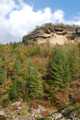
Site Description: The Big South Fork NRRA preserves the canyon of the Big South Fork of the Cumberland River and two tributaries, Clear Fork and the New River, that merge to create the Big South Fork, as well as many other tributaries that flow into it. The Big South Fork River flows northward through the park for about 49 miles and is free-flowing for about 37 miles until it is affected by the headwaters of Lake Cumberland. Many canyon walls in the park are quite imposing, as viewed from the abundant available overlooks, and there are many other rock formations, including arches and rock houses, that provide scenic opportunities for visitors.
The park is largely forested with most of the forest being 50-70 years old, but some pockets of older growth exist. "The general forest type is mixed-oak with mixed-mesophytic pockets. This is divided into an upland community on the plateau and a ravine community. The upland vegetation types range from Red Maple-dominated stands on poorly-drained flats to Virginia Pine-dominated stands on dry ridges and cliff edges. On the broad flats and gentle slopes are the mixed oaks with hickory. Ravine communities are generally dominated by more mesic species--Beech, Sugar Maple, and Yellow Birch-with oaks on the middle and lower slopes. Hemlock is prominent in the narrow gorges and along streams. River Birch and Sycamore typify the floodplains" (National Park Service). In the lower levels of the gorge a forest of Eastern Hemlock and White Pine with rhododendron understory is quite common. Significant changes to a large portion of the forest took place during 1999-2003 when an outbreak of southern pine beetle occurred, reducing by more than 50% the evergreen component of the park's forests (Stephen J. Stedman).
Extensive trail systems have been developed for equestrian uses in recent years. Hikers should heed caution for horses on hiking trails that are human foot traffic only. Large numbers of trucks and trailers may be found on park roads at times.

Wildlife to Watch: The site is a large, mature forest that contains a high density of Neotropical species and individuals. Some common breeding birds are Red-eyed Vireo, Ovenbird, Hooded Warbler, Indigo Bunting, Black-throated Green Warbler, Scarlet Tanager, Worm-eating Warbler, and Pine Warbler. Sharp-shinned Hawk, Swainson's Warbler, and Blue-headed Vireo are exceptional nesting birds in the area. Swainson's Warblers can be found along steep gorges with thick vegetation, but they are uncommon and not always detected. Mink may be seen in some areas. White-tailed deer and Wild Turkey are commonly seen around the park. Some overlooks can be good for migrating raptors in September and October.
Northern Saw-whet Owls can be found in winter with some regularity, but much effort is needed to locate these birds.
Steve Stedman's web page on Saw Whet Owls.
NOTE: Please refer to TWRA Hunting Guide about hunting seasons and public access dates. Access dates vary by site.
For more information:
National Park Service web page
Bird data from the Big South Fork NNRA
Submit your data to eBird and help us build a list of birds seen at this site
Be sure to check out our Safety Tips page for important information regarding viewing wildlife in these areas.


