Ensley Bottoms Complex (The Pits, TVA Lakes, Riverport Rd.)
SW Memphis near the Chucalissa Museum and T.O. Fuller State Park
Memphis, TN
Site Directions: See below for detailed directions, but ONGOING construction project AND resulting theft and vandalism has made ACCESS limited due ot installation of a security gate, so plan accordingly
Seasonality: year round
Fees: none
Landmarks: Chucalissa Museum
Site Description: The site consists of an array of sewage sludge drying ponds - some dry and some flooded. Shallow water/mudflat habitat attractive to shorebirds is abundant and large numbers of shorebirds frequent the area. The area is not open to the general public but birders are allowed to enter. Caution: The disagreeable odors from the sludge drying ponds can be overwhelming. After rain, dirt roads are extremely slippery and caution must be taken. Never take risks while driving in and birding this area.
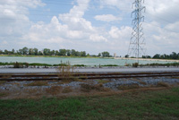
TVA Lakes is another waste water storage pond which attracts shorebirds, waterfowl like Black-bellied Whistling Ducks, and gulls and terns. Both scaup can be found in winter, making for a nice study of the species side-by-side. A Neotropic Cormorant was found here in August 2012.
Riverport Road ponds are borrow pits that are flooded during high water and have waterfowl in winter or marhs birds in spring and summer, but may become shallow for wading birds or shorebirds.
Painted Bunting location may soon be closed to all visitors due to criminal activity in the area. The scrubby areas are good for birds, including Painted Buntings, but heed caution when in the area.
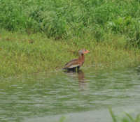
Wildlife to Watch: This area is an excellent place to observe and compare a wide variety of shorebirds. Due to the concentrations of shorebirds that may be present (thousands), the site also attracts raptors such as the Peregrine Falcon which feed on other birds. Black-bellied Whistling Ducks nested here in 2008-2011, with up to 43 birds spending winter 2011-12 on site. Bell's Vireo, Loggerhead Shrike, and Painted Bunting may also be found nesting here. Bobolinks and Upland Sandpipers can be found in open grassy areas in late April and early May. Black-necked Stilts nest on the wastewater ponds. Waterfowl can be abundant in winter with regular rarities being found, including all 3 scoter species and Long-tailed Duck. Countless rare birds in Tennessee have been found in this area.
For more information:
Tennessee Ornithological Society - Audubon Important Bird Area web page
Birds of Ensley Bottoms from eBird submissions
Detailed directions for birding the Ensley area:
From I-55, take exit 9, Riverport Rd, south for 4.0 miles to the intersection with Plant Rd (on your right) and Buoy Rd (on your left). Going right onto Plant Rd takes you to the TVA Lakes, while going left onto Bouy Rd takes you to the Ensley Sewage ponds.
TVA Lakes - From Riverport Rd, turn RIGHT onto Plant Rd (from directions above). Once you turn right onto Plant St., you go only 0.1 miles, traveling up a slight hill, and turn RIGHT onto a dead end road. The ponds on your LEFT are the TVA Lakes.
Lat-Long for the main TVA Lake: 35.069819,-90.135358
Riverport Rd Ponds - the ponds are on the left just before the entrance to T.O Fuller State Park, see above directions.
Lat-Long for the ponds: 35.068643,-90.100557
TVA Lake - the main pond for birding
*TVA Security is encouraging people to not get out of their vehicles for personal safety reasons. If you get out of your vehicle to bird watch and encounter TVA Security, please do what they request of you.
Ensley Sewage ponds - *** PLEASE NOTE THAT DUE TO ONGOING CONSTUCTION ON SITE AND INCREASE IN THEFT AND VANDALISM A NEW FENCE IS BEING INSTALLED AT THE ENTRANCE TO THIS LOCATION. IT WILL BE LOCKED AFTER BUSINESS HOURS AND ON SUNDAYS SO PLAN ACCORDINGLY. THIS IS THE ONLY WAY INTO THE SEWAGE PONDS THE 'BACK' LOCATION HAS BEEN BLOCKED. ALSO NOTE THAT ONCE INSIDE IF GATE GETS LOCKED YOU'RE 'STUCK' SO PLAN ACCORDINGLY.
From the 4-way intersection of Riverport Rd and Plant and Bouy Rds, turn left onto Buoy St towards the sewage ponds. Once on Buoy St, travel 0.2 miles to a 90 degree right turn. At this bend in the road, travel more or less straight into the parking lot for the work shop at the sewage ponds.
Lat-long for entrance to the Ensley Sewage ponds complex: 35.064551,-90.138491
Roads around the sewage ponds are open to vehicle traffic, but HEED CAUTION and drive only on well graveled and well traveled roads. Never take risks with your vehicle or when on foot. Rainy conditions can be some of the best times for bird watching at this site, but be very cautious as roads can be very slippery.
Once you pass the work shop, we suggest you make a LEFT turn. After turning left, make a RIGHT turn in only 200 ft on a wide gravel road. The ponds on both sides of the road can be excellent for shorebirds. As you travel south on this road, you have a couple options for viewing ponds. First, you can turn RIGHT onto the first gravel road on the right which takes you between a series of long skinny ponds (35.059246,-90.138629). Second, continue past the first gravel road until you reach a "T" (hereafter referred to as the "T") (35.056208,-90.138414). You can drive along a narrow gravel levee to the left, however it's best to park off the shoulder at the "T" and walk from here as the road is often grown up in spring through fall and a turnaround in the woods is difficult to navigate unless you are very familiar with the area. From the "T", you can also park off the road and walk up the taller levee in front of you to the right. From the top of the levee, you can look down into the three ponds here (35.055013,-90.139607). Third, from the "T", make a right (taller levees are now on your left) and drive this main gravel road west towards drier fields. Following the road from the "T" to the right will connect you with additional wide gravel roads and with the original Riverport Rd (also marked as Paul Lowery Rd in Google Maps).
Other dirt roads around the ponds are technically open to vehicles, but to ensure continued birding at this sites, DO NOT DRIVE ANY NARROW DIRT ROADS!! Be cautious on all roads! Never take risks!
Although the main ponds and locations described above are where the majority of shorebirds tend to be found, but Upland Sandpipers, Buff-breasted Sandpipers, and American Golden Plovers are usually seen in the drier fields in the area.
Riverport Road Ponds
After turning onto Riverport Rd from I-55, travel approximately 3 miles and a series of ponds are on your left (35.068643,-90.100557). These areas can support a variety of shorebirds and wading birds (when water is low), Anhinga and Least Bittern in spring and summer, and waterfowl in winter. These ponds are always worth checking. Wood Storks and Roseate Spoonbills were present in August 2012. A wide shoulder on the road makes birding here relatively safe, but be aware of a large number of tractor trailers!
Painted Bunting location - Allen Steam Plant
*Reports are that TVA Security has closed this area to all access due to criminal activity occurring in the area. If you choose to drive down into this location, we suggest you do not get out of your vehicle. Historically we have been able to walk the sandy road through the scrubby area, but that is now prohibited.
One of the few reliable places for Painted Bunting in Tennessee is near the TVA Allen Steam Plant. From Riverport Rd, continue past the entrance to T.O Fuller State Park for 0.4 miles (or 3.2 miles total once you turn onto Riverport Rd) and turn RIGHT onto Plant Rd as if you were going to TVA Lakes. Once you turn onto Plant Rd, travel 0.9 miles on the paved road to a right turn onto an unnamed and unmarked gravel road (35.072243,-90.151289). Travel 0.4 miles on the gravel road, following around a 90 degree right bend and a quick 90 degree left bend in the road, passing sewage ponds on the left (look for shrikes on the wire) and the right turn is the SECOND gravel road on the right which bares off to the right and down a hill. The road ends at a gate in 75 yards. We recommend parking on the side of the road at the bottom of the hill and listen for Painted Buntings. Do not park on the gravel road before dropping off the levee as they water the road down regularly to reduce dust and your vehicle may get sprayed with non-potable water.
Once finished birding this area, consider driving north on Florida St passing over I-55 and head towards President's Island. On President's Island you can find White-winged Dove (if you're really lucky), Western Kingbird, Scissor-tailed Flycatchers, and Painted Buntings.
Lat-Long (GPS) coordinates
Entrance to Ensley Sewage Ponds: 35.064515,-90.138511
TVA Lakes: 35.069512,-90.135775
Riverport Road Ponds: 35.068643,-90.100557
Submit your data to eBird and help us add to the list of birds seen at this site
Be sure to check out our Safety Tips page for important information regarding viewing wildlife in these areas.