Old Hickory Dam, "Snow Bunting" Peninsula, Vicinity
Site Directions:
There are many places to access Old Hickory Lake for wildlife watching. The following lists directions to several popular locations for bird watching. See links below for more information. The directions below provide a route from south of the dam to north and east with a fairly easy path to follow for a day of birding.
Old Hickory Lake lies north of Nashville on the Cumberland River. Birding is best in the fall, winter, and spring. There are many access points, but most birding is done on the south side near the dam and along Drakes Creek on the north side.
The Old Hickory Dam area can be reached by taking the Old Hickory Blvd exit from I-65 north of the city. (Rt. 45). Head south on Rt. 45 across Gallatin Road and continue across the Cumberland River. Take the second left after crossing the bridge. This is Bridgeway Ave. Turn left onto Ensley Ave and continue across train tracks to a stop sign and make a left onto Swinging Bridge Road. Then take the first right (Burnett Road). Follow this road down to a gravel area which juts out into the lake. This is "Snow Bunting" Peninsula. There is a public swimming beach in the area as well, which is open in summer. The peninsula is known to birders as "Snow Bunting" Peninsula due to the presence of 2 Snow Buntings during the winter of 1969-70. Strangely enough, 30 years later, a Snow Bunting was present for a few days on this same peninsula, thus reinforcing the site's name.
Old Hickory Lake Park and Snow Bunting Peninsula-
Lat-Long: 36.28756, -86.65756
A large part of the lake can be scanned from Snow Bunting Peninsula, frequently yielding cormorants, grebes, ducks, herons and gulls. Recent rare and uncommon birds found on or seen from Snow Bunting Peninsula include "Western" Willets, Marbled Godwit, American Avocet, Buff-breasted Sandpiper (rare spring record for TN), Piping Plover (rare spring record for TN and there were 2 birds, one was banded 10 years earlier in Saskatchewan), Laughing Gull, Parasitic Jaeger, Magnificant Frigatebird, Red Knot, Dunlin, Pectoral Sandpiper, Peregrine Falcon, among other shorebirds, gulls, terns, and ducks. Caspian, Common, Forster's, and Black Terns were photographed together in 2011.
To get to the dam from the Peninsula, go back to Swinging Bridge Road, turn right and go to the next street on the right (Cinder Road). Follow this back to the water. A large parking area next to the beach provides another access point for scanning the lake. The road to the left leads to the dam. Bear left and continue down to the river below the dam. Black-crowned Night Heron are frequently seen along the bank and in the trees on either side of the river. Gulls are generally present near the spillway.
The Nature Trail is also located here.
Nature Trail and Dam overlook- Lat: 36.29598, -86.65932
The nature trail at the dam provides a nice mix of forest birds and is one of the few places in middle Tennessee to find Pine Warblers. Barred Owls are common in the forest along the dam trail. In winter, Red-breasted Nuthatches may be present. Lesser Black-backed Gull has been found at the dam in recent years.
To get to the north side of the dam, retrace your route back to Old Hickory Blvd. Turning right onto Old Hickory (Rt.45) go back to I-65 and head north. Take the Vietnam Veteran's Blvd exit. This is also a limited access highway. Continue to the interchange for Hwy 31 (Exit 3), Gallatin Rd. Head south to Gallatin Rd and then east making a right on Rockland Rd in only 0.1miles. Follow signs to Rockland Recreation Area (Lat-Long: 36.300064,-86.647809). Access the dam and open water from the park.
To continue towards the Drakes Creek area, first retrace your steps back to Rockland Rd and make a right towards Gallatin Rd. Make a right on Gallatin Rd (east) and follow to Sanders Ferry Rd. If you bypass the Rockland Recreation Area and are arriving from Vietnam Veterans Blvd, exit Vietnam Veterans Blvd at the New Shackle Island Road exit and turn south to Gallatin Pike (US 31). Take Gallatin Road towards Hendersonville to Drake's Creek, which will be on the right. The lake can be scanned from behind Mallards Restaurant (Lat-Long: 36.30423, -86.61529) on the corner of Gallatin Pike and Sanders Ferry Road. There are several access points along Sanders Ferry Road which provide good water views. There is a small parking lot, not marked, just north of a marina for viewing the rookery on Drakes Creek (Lat-Long: 36.26619, -86.60785).
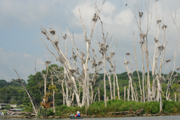
Rookery at Drakes Creek.
Sanders Ferry Park is located at the end of the peninsula on Sanders Ferry Rd. (Lat-Long: 36.25331, -86.60381). The park is accessed by making a left at a stop sign to stay on Sanders Ferry Rd. There should be a sign marking the park. Sanders Ferry Park provides several lake views and fishing piers for viewing. Gulls, terns, loons, and waterfowl may be found, along with swallows, in season.
Continue on around the peninsula by retracing path to Sanders Ferry Rd at the 4-way stop sign, making a left and staying on Curtis Cross Road to a school and intersection with Walton Ferry Road that takes you back north. There are several access points off Walton Ferry Road, including an environmental area which has several large fields which are good for sparrows in the winter. Lock 3 Recreation area is off Walton Ferry Rd providing a good westward view of the lake (Lat-Long: 36.27719, -86.63128).
Hours: daylight hours, but camping is available at designated locations
Seasonality: year round
Fees: none
Site Description: There are patches of hardwood forest of oak, hickory, and maple, and riparian forest of Black Willow and sycamore along the shoreline of parts of the lake. Most of the habitat surrounding the lake is urban/suburban development including several recreation areas (noted above) with beaches, trails, picnic and camping facilities, including the nature trail at the dam. Public floodplain land has been allowed to be manicured and incorporated into yards by adjoining landowners over much of the area thus reducing wildlife habitat.
Wildlife to Watch: The largest breeding colonies of wading birds in the Central Basin are located on Old Hickory Lake. Black-crowned Night Herons are abundant breeding birds, as are Great Blue Herons, Cattle Egret, and Great Egrets. Double-crested Cormorants are increasing in abundance annually. There are breeding Ospreys around the lake. Transient and wintering waterfowl, loons, grebes, gulls, terns, and swallows are also common in season. A variety of sparrows, including Field (year round), Swamp, White-throated, and Song Sparrows are found in grassy fields and field edges. Scan open sandy areas for Horned Larks and Killdeer and rarities that might stop in. In winter, large numbers of Bonaparte's and Ring-billed Gulls are often found around the dam and across the lake. Waterfowl can be abundant in winter, but also be sure to look for Common Loons and Red-breasted Mergansers.
Please see Old Hickory WMA and Old Hickory Lake- Lock 5 Refuge for other locations in the area.
For more information:
Snow Bunting Peninsula (aka Metro Beach Swim area Map
Birds of Old Hickory Dam area from eBird submissions
Birds of Old Hickory Lake from eBird submissions
Rockland Recreation Area map
TWRA Boat Ramp Access maps
Submit your data to eBird and help us add to the list of birds seen at this site
Be sure to check out our Safety Tips page for important information regarding viewing wildlife in these areas.